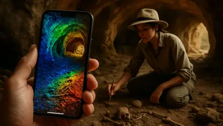

Smartphone technology is rapidly transforming fields far beyond communication, and its latest leap into archaeology could redefine how ancient sites are studied and preserved, especially in challenging environments like caves. Imagine a researcher navigating the shadowy depths of a prehistoric cavern, armed not with bulky, expensive equipment, but with a device as common as a smartphone, capturing intricate 3D models of millennia-old art and formations. This isn’t a distant dream—it’s a reality being pioneered by a team from the University of Seville in Spain. Their recent study focused on La Pileta Cave in Málaga, a site brimming with over 1,200 graphic motifs from the Upper Paleolithic to the Bronze Age, spanning roughly 30,000 years. By pairing smartphone LiDAR with professional-grade tools, they’ve created a stunning digital replica of the cave, hinting at a future where high-quality archaeological documentation is within reach for many more scholars and heritage enthusiasts.
Unlocking Ancient Mysteries with Modern Tech
The potential of smartphone LiDAR, or Light Detection and Ranging, lies in its ability to map environments in three dimensions using laser pulses that measure distances by timing light reflections. Unlike Terrestrial Laser Scanning (TLS), which offers pinpoint accuracy but comes with a hefty price tag and logistical challenges, smartphone LiDAR provides a portable alternative. Though limited to a range of about 5 meters and less precise, it generates real-time textured 3D meshes with remarkable ease. In the case of La Pileta Cave, researchers combined data from a device like the iPhone 15 Pro with TLS benchmarks, cross-referencing against topographic control points. The result was a digital model with minimal error, demonstrating that consumer-grade technology can stand shoulder to shoulder with professional systems in visual fidelity, especially when thoughtfully integrated.
This breakthrough isn’t just about the tech—it’s about redefining access to archaeological research. La Pileta Cave, with its labyrinthine passages and dramatic vertical drops, has long resisted full documentation due to its inaccessibility. Traditional methods often required cumbersome setups that risked damaging fragile surfaces or were simply infeasible in tight spaces. Smartphone LiDAR sidesteps many of these issues with its handheld nature, allowing researchers to maneuver through narrow corridors and capture detailed scans without invasive equipment. This adaptability suggests a seismic shift, where documenting remote or delicate sites no longer demands vast budgets or specialized training, opening the field to a broader spectrum of contributors.
Navigating the Challenges of Cave Documentation
Documenting a cave environment is a task fraught with obstacles, from absolute darkness to uneven terrain that can confound even the most advanced tools. In the study of La Pileta Cave, the team faced the daunting challenge of lighting, relying on LED lanterns and custom 3D-printed mounts to stabilize their smartphones during scans. The limited range of smartphone LiDAR meant multiple overlapping scans were necessary, each covering just a few meters, while the lack of texture on smoother cave walls occasionally reduced accuracy. Post-processing also proved labor-intensive, with weeks spent aligning massive datasets to ensure precision against TLS standards. Despite these hurdles, the hybrid approach excelled in rendering complex formations like speleothems, proving its worth in rugged settings.
Beyond technical difficulties, the physical environment of a cave adds layers of complexity to such projects. The absolute isolation and often damp conditions demand resilience from both equipment and researchers, as even minor errors can skew data in spaces where every detail matters. Smartphone LiDAR’s portability became a critical asset here, enabling scans in areas where setting up heavy TLS gear would be impractical or impossible. While challenges like managing battery life in prolonged fieldwork and ensuring consistent lighting persist, the success in capturing intricate cave features signals that these barriers are surmountable. This adaptability underscores the potential for smartphone technology to become a staple in archaeological fieldwork, even in the most unforgiving locations.
Preserving Cultural Treasures for Generations
La Pileta Cave stands as a monumental archive of human history, its walls adorned with rock art that offers glimpses into prehistoric life across Europe over tens of thousands of years. Features like the Gran Pez chamber and the Gran Sima abyss are not just geological wonders but cultural touchstones that demand careful preservation. The use of smartphone LiDAR to create detailed 3D models marks a significant advance in safeguarding such sites. These digital replicas allow for in-depth study without the risk of physical wear from repeated visits, ensuring that delicate paintings and formations remain untouched by modern interference while still being accessible for research purposes.
The implications of this technology extend far beyond mere documentation. By crafting high-fidelity digital models, researchers can analyze spatial relationships within the cave—how art aligns with natural features, for instance—that might be missed during on-site visits. This non-invasive approach also protects the cave from potential degradation caused by environmental changes or human presence, a growing concern for many heritage sites. Moreover, the ability to revisit these models repeatedly in a virtual space enables ongoing analysis without further endangering the physical site, offering a sustainable way to engage with history. This balance of preservation and study highlights how smartphone LiDAR can serve as a guardian of cultural legacy in an era of increasing environmental threats.
Breaking Down Barriers in Archaeological Access
One of the most transformative aspects of smartphone LiDAR is its role in democratizing archaeological documentation. High-end TLS systems often carry prohibitive costs, limiting their use to well-funded institutions and excluding smaller organizations or independent scholars from cutting-edge research. By contrast, smartphone technology slashes these financial barriers, requiring little more than a compatible device and accessible software to produce quality 3D scans. The study at La Pileta Cave illustrates how this affordability can empower a wider range of researchers to contribute to heritage preservation, leveling the playing field in a field often constrained by resources.
This democratization doesn’t stop at academia—it reshapes public engagement with history. Virtual models derived from smartphone LiDAR scans enable anyone with internet access to explore remote sites like La Pileta Cave, regardless of physical mobility or geographic location. Educators can integrate these immersive experiences into curricula, while conservationists gain tools to monitor site conditions without invasive methods. This accessibility fosters a deeper appreciation for cultural heritage among diverse audiences, bridging gaps between specialized research and public curiosity. As a result, the technology not only enhances scientific endeavors but also builds a global community around the shared mission of preserving the past.
Charting a New Course for Heritage Innovation
The integration of consumer-grade tools like smartphone LiDAR into archaeology reflects a broader trend toward inclusivity and innovation in scientific research. Experts in the field increasingly agree that affordable devices can complement or even substitute for expensive systems like TLS, particularly when validated against established benchmarks. The success at La Pileta Cave serves as a compelling case study, showing that quality need not be sacrificed for cost. This shift encourages smaller institutions and independent researchers to participate in documenting and conserving heritage sites, amplifying the collective effort to protect history.
Looking ahead, the potential for refining this technology is immense. Future developments could enhance smartphone LiDAR’s range and accuracy, while integrating additional methods like photogrammetry might yield even richer digital models. Plans to create open-access 3D archives also promise to expand virtual access, ensuring that sites like La Pileta Cave are studied and appreciated by generations to come. This forward momentum suggests that archaeology stands on the brink of a technological renaissance, one where the tools of preservation are as ubiquitous as the smartphones in countless pockets, ready to capture the past with unprecedented ease and impact.