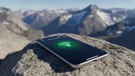

A solitary hiker navigating the rugged peaks of the Sierra Nevada no longer faces the terrifying prospect of total isolation if an ankle snaps miles from the nearest trailhead. While wilderness excursions used to require specialized, expensive hardware to maintain a lifeline to the outside world, the latest generation of smartphones has effectively integrated satellite connectivity into the pockets of the general public. This technological shift is fundamentally altering the landscape of backcountry safety, moving away from a reliance on dedicated emergency beacons toward a more accessible, software-driven ecosystem. As satellite SOS features become standard in consumer electronics, the barrier to summoning professional help has virtually vanished for the average weekend adventurer. This democratization of rescue technology presents a significant leap forward in personal security, yet it simultaneously introduces a new set of complexities for the specialized organizations that monitor these distress signals and coordinate life-saving responses in remote environments.
Comparing Specialized Gear and Consumer Phones
Hardware Reliability: Ruggedness and Accuracy
The debate between dedicated satellite messengers and modern smartphones often centers on the physical resilience required to survive a catastrophic event in the wilderness. Dedicated devices, such as those produced by Garmin or Zoleo, are engineered with high-impact plastics, waterproof seals, and physical buttons that function even when the user is wearing heavy gloves or dealing with freezing rain. In contrast, the glass-heavy construction of a smartphone remains a significant point of vulnerability, as a single drop onto a granite slab can shatter the interface required to send an emergency signal. Despite these physical differences, the internal technology powering location services has seen a remarkable convergence in terms of raw performance. Modern smartphones now utilize multi-constellation GPS chips that provide search and rescue teams with coordinates accurate to within ten meters, matching the precision of professional-grade survival equipment.
Building on this technological parity, the integration of high-gain antennas within slim smartphone chassis has proven more effective than many skeptics initially predicted. While a dedicated Personal Locator Beacon may still offer a stronger signal in deep canyons or under dense forest canopies, the gap is narrowing as satellite networks expand their reach. Experts from the Colorado Search and Rescue Association have noted that the data provided by smartphone SOS activations is consistently reliable, allowing ground teams to pinpoint a subject’s location with extreme confidence. However, the reliance on a touchscreen interface remains a double-edged sword; while it allows for detailed messaging, it is far more susceptible to failure in extreme weather conditions compared to the tactile, simplified controls of a dedicated messenger. Consequently, while the internal accuracy of the smartphone is now unquestionable, its overall survivability in a true survival situation depends heavily on the user’s ability to protect the device.
Battery Life: Power Management in the Wild
One of the most critical distinctions between a consumer phone and a specialized satellite unit involves the longevity of the power source under continuous operational stress. Dedicated satellite messengers are designed for extreme efficiency, often capable of operating for several weeks on a single charge while periodically broadcasting a tracking signal. This endurance is a direct result of their limited feature sets and low-power displays, which do not compete for energy with high-resolution screens or background applications. A smartphone, by its very nature, is a power-hungry device that must manage dozens of concurrent processes, often leading to rapid battery depletion if not meticulously managed. In cold environments, the lithium-ion batteries found in smartphones are notorious for losing their charge or shutting down entirely, creating a high-risk scenario where the lifeline to rescue services could vanish at the very moment it is needed most.
To mitigate these risks, seasoned outdoor professionals continue to advocate for a redundancy-based approach to remote safety. Carrying a power bank or a small solar charger is no longer just a convenience for the digital-savvy hiker but has become a mandatory component of a modern survival kit when relying on a phone as the primary communication tool. Furthermore, the practice of keeping the device in an insulated pocket close to the body can help maintain internal temperatures and preserve battery life during winter excursions. While the smartphone offers an incredible all-in-one solution for navigation, photography, and emergency communication, its inherent fragility and power limitations mean it should rarely be the sole piece of safety equipment on a multi-day trip. The most effective strategy involves utilizing the phone for its versatile features while keeping a dedicated beacon as a deep-reserve option, ensuring that a communication failure does not become a fatal error.
The Impact on Search and Rescue Operations
Communication Efficiency: Two-Way Texting Benefits
The transition from one-way emergency signals to robust two-way satellite texting has revolutionized how dispatchers manage remote emergencies. In the past, a basic Personal Locator Beacon could only transmit a “help” signal with a set of coordinates, leaving rescuers in the dark regarding the nature of the injury or the equipment required for the extraction. Modern satellite features in smartphones allow for a real-time dialogue between the distressed party and a professional dispatcher, which provides critical context before a team is even deployed. Rescuers can now ask specific questions about the patient’s vitals, the terrain conditions, and the current weather at the site. This flow of information ensures that when a helicopter or ground team finally arrives, they are equipped with the exact medical supplies and specialized gear needed for that specific scenario, significantly increasing the efficiency of the entire mission.
This interactive capability also introduces the possibility of self-rescue, a concept that was previously much harder to coordinate from a distance. If a hiker is merely disoriented or facing a minor mechanical issue with their gear, a dispatcher can provide turn-by-turn navigation instructions or technical advice via text. By guiding a person back to the trail or helping them stabilize a minor injury, search and rescue organizations can resolve incidents without the need for a physical deployment. This preservation of resources is vital, as it keeps personnel and aircraft available for more severe, life-threatening situations elsewhere. The ability to distinguish between a broken leg and a lost water filter through a simple text thread has turned the smartphone into a sophisticated triage tool that benefits both the adventurer and the rescue system. Moreover, this constant contact provides a massive psychological boost to the victim, reducing panic during the long wait for help.
New Challenges: Managing the Influx of Calls
While the accessibility of satellite SOS has undoubtedly saved numerous lives, it has also created an unprecedented administrative burden for emergency services. Because the “barrier to entry” for calling for help has been lowered to a simple button press on a device everyone already carries, there has been a noticeable increase in distress calls for non-critical issues. Search and rescue teams are increasingly forced to deal with “convenience calls” from individuals who are tired, caught in a light rainstorm, or simply frustrated by their progress on a trail. This influx of low-priority messages requires constant monitoring and triage, pulling focus away from more urgent tasks. Dispatchers must now act as gatekeepers, carefully vetting every incoming satellite text to determine if a full-scale response is warranted or if the user simply needs a stern reminder about the realities of outdoor recreation.
This shift has also highlighted a growing concern regarding the psychological reliance on technology, often referred to as the “digital tether.” When hikers feel that help is always just a text message away, they may be more inclined to take unnecessary risks or head into environments for which they are poorly prepared. This perceived safety net can lead to a dangerous erosion of traditional wilderness skills, such as map reading and terrain assessment. For search and rescue volunteers, who often operate on limited budgets and personal time, the rise in preventable rescues is a significant point of frustration. The challenge for the coming years will be to educate the public on the proper use of these life-saving tools, emphasizing that an SOS activation should be a last resort rather than a primary solution for poor planning. Maintaining a balance between technological empowerment and personal responsibility remains a central theme in modern backcountry safety.
Market Availability and Traditional Preparedness
Device Ecosystems: Networks and Partnerships
The current landscape of smartphone satellite SOS is defined by a fragmented array of hardware requirements and service provider agreements. Apple currently leads the sector with its integrated emergency features, utilizing the Globalstar satellite network to provide coverage across North America and beyond. Meanwhile, Google has expanded its capabilities by partnering with the Skylo network for its latest Pixel devices, ensuring that Android users have a comparable safety net. The complexity increases when considering carrier-specific deals, such as the collaboration between T-Mobile and various satellite operators to provide broader connectivity to a wide range of devices. This variety means that a user’s ability to call for help often depends on their specific hardware model and their service contract, creating a confusing environment for consumers who may not fully understand the limitations of their particular device.
Beyond the major manufacturers, the role of satellite providers like SpaceX and Iridium is becoming increasingly central to the consumer experience. These companies are working to provide direct-to-cell connectivity, which aims to eliminate the need for specialized satellite chips altogether by allowing standard phones to connect directly to orbiting constellations. While this promises a future of ubiquitous coverage, current users must still navigate a patchwork of compatibility. For instance, some satellite features may only work for emergency SOS, while others allow for casual check-in texts or location sharing with family members. This distinction is crucial for backcountry travelers to understand before they leave cellular range. Ensuring that a device is properly updated and that the user is familiar with the specific activation sequence for their model is now a mandatory part of trip preparation, as the technology is not yet a universal, “plug-and-play” utility across all brands.
Essential Planning: The Human Element of Safety
Despite the incredible advancements in satellite communication, technology can never serve as a total replacement for fundamental wilderness preparedness and common sense. A dead battery, a deep slot canyon, or a simple software glitch can instantly render a thousand-dollar smartphone useless in a crisis. This is why experts continue to emphasize that the most powerful safety tool is a detailed trip plan left with a reliable person back at home. This “analog” fail-safe ensures that if a hiker does not return by a specified time, a search will be initiated even if no SOS signal was ever sent. A comprehensive plan should include the intended route, expected timelines, vehicle descriptions, and any medical conditions of the participants. This traditional practice remains the backbone of the search and rescue system, providing a guaranteed trigger for assistance that does not rely on electronics, signals, or satellite constellations.
In summary, the integration of satellite SOS into smartphones represented a significant evolution in outdoor safety, yet the most effective approach involved a blend of modern tech and classic skills. Users who chose to rely on their phones were advised to carry external power sources and to test their satellite features in a non-emergency setting before heading into the field. The community eventually recognized that while a two-way text could save a life, it did not replace the need for a physical map, a compass, and the knowledge of how to use them. Organizations successfully navigated the influx of calls by implementing stricter triage protocols and public education campaigns focused on self-reliance. Ultimately, the successful backcountry traveler was the one who treated the smartphone as a valuable supplement to, rather than a replacement for, the essential practices of planning and precaution. Moving forward, the industry prioritized the development of more resilient hardware to ensure these digital lifelines remained functional in the most demanding conditions imaginable.