
Architectural heritage functions as an open-air memory archive where evolving social practices and communal identities are preserved within the physical fabric of buildings. This legacy, however, is perpetually under threat from rapid urbanization, environmental decay, and economic limitations that render traditional physical restoration nearly impossible for many vulnerable sites. Maintaining the physical authenticity of historic architecture is a multifaceted and multidisciplinary endeavor that often demands exhaustive documentation, extended timelines, and immense financial resources. When these practical barriers become insurmountable, high-value heritage structures are frequently left to deteriorate, resulting in the permanent loss of both tangible craftsmanship and the intangible cultural narratives of the communities that built them. In response to these compounding challenges, the global conservation community is turning toward immersive visualization and mobile computing as a bridge between the past and the present. By leveraging digital workflows, it is now possible to significantly reduce the operational workloads and budgets that typically stall restoration initiatives, offering a survival strategy for heritage that would otherwise be forgotten. Mobile Augmented Reality Platforms (MARP) and Mobile Augmented Reality Restoration (MARR) represent a transformative shift, providing a mechanism to safeguard spatial understanding even when the physical stones have crumbled beyond the point of immediate repair.
1. Addressing Restoration Challenges through Digital Innovation
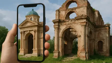
The core utility of mobile augmented reality platforms lies in their ability to bridge the gap between archaeological ruins and their former architectural glory through real-time digital overlays. Recent investigations into this technology highlight how consumer-grade hardware is democratizing the restoration process by making sophisticated visualization accessible to both the public and professionals. By utilizing mobile units that visitors already carry in their pockets, the prohibitive costs and logistical hurdles associated with specialized industrial equipment or heavy-duty VR setups are effectively eliminated. These systems allow for a qualitative inquiry into historical structures, where digital reconstructions are superimposed directly onto surviving physical foundations. This strategy emphasizes that while digital restoration cannot replace the material integrity of a building, it provides a crucial stopgap that prevents the total erasure of a site’s spatial history. Through iterative research and deployment, mobile platforms have demonstrated that they serve as a viable alternative for visualizing lost morphology, allowing users to experience the intended aesthetic and structural volume of a building that has been reduced to its foundations over time.
The conceptualization of heritage as a dynamic archive rather than a static object is central to the adoption of augmented reality in the conservation field. Physical restoration must prioritize structural stability and material authenticity, but visualization platforms are specifically intended to safeguard the architectural knowledge of the building. This includes the documentation of spatial organization, construction systems, and ornamentation that define a culture’s unique identity. For instance, in projects focusing on Malay colonial heritage, researchers have used digital frameworks to reconstruct ruined houses, ensuring that future physical reconstructions can be based on accurate, high-fidelity data. This approach acknowledges that while current economic and technical conditions might prevent a full material rebuild, the digital preservation of architectural knowledge ensures that the site remains an active participant in cultural discourse. By shifting the primary focus from physical stones to digital data preservation, these projects provide a resilient pathway for cultural continuity that is resistant to the physical decay of the original environment.
2. The Evolution of Heritage Visualization Systems
The journey toward modern mobile restoration began with pioneering systems that first demonstrated the potential of layering digital reconstructions over physical ruins. One notable precursor was ARCHEOGUIDE, a system designed for cultural heritage tourism that provided educational site experiences through augmented overlays. Its technical architecture relied on a complex client-server configuration, consisting of a central site information server and mobile units carried by visitors. These units were connected via a dedicated dual-network wireless infrastructure, which was groundbreaking for its time. However, these early systems were often hindered by the physical weight of the equipment, which included laptops and bulky head-mounted displays. Despite these logistical constraints, they established the foundational design precedents for personalized, on-site historical exploration. These early experiments proved that providing contextual multimedia information directly at an archaeological site could significantly enhance public understanding of history, even if the hardware was not yet optimized for widespread consumer use.
Building on these foundations, modern mobile platforms have transitioned away from cumbersome configurations toward streamlined applications that run on standard smartphones and tablets. Contemporary systems utilize natural user interfaces and integrated device sensors to provide a much more seamless and intuitive experience. The evolution from specialized, low-frequency GPS correction beacons to modern integrated positioning systems has allowed for greater flexibility in how visitors interact with heritage sites. Unlike their predecessors, modern mobile augmented reality restoration frameworks integrate a cloud computing backend, allowing for the real-time transmission of high-resolution architectural data over the internet. This shift has not only improved rendering speeds but has also allowed researchers to manage expansive datasets that include spatial organization, building components, and decorative fixtures. By moving the heavy computational lifting to the cloud and the interface to the smartphone, the technology has finally reached a level of portability that makes it a practical tool for everyday heritage management and tourism.
3. Implementing the MARR Development Workflow
The creation of a digital restoration project follows a structured sequence designed to ensure accuracy and performance. The first phase of this workflow is essential for establishing the factual basis of the digital model:
- Conduct field surveys and gather documentation. Researchers perform detailed physical measurements, including contact measuring and tracing, while conducting literature reviews and oral interviews to capture the history of the site. This stage also involves capturing authentic surface textures and materials through specialized mapping techniques to ensure the virtual model reflects historical reality.
- Build virtual models of the structures. Digital versions of the buildings are created using advanced modeling software and organized into modular strata, such as construction systems and ornamentation. This layered categorization is critical for reducing three-dimensional file sizes, which in turn optimizes rendering speeds on mobile devices while still preserving the technical metadata required by restoration teams.
The subsequent phases of the workflow focus on the deployment and live interaction of the digital assets at the physical site, ensuring the virtual and physical worlds align perfectly:
- Establish a cloud-based communication network. A robust data pipeline is set up to connect mobile devices to cloud storage, allowing for the real-time transfer of 3D assets. This ensures that the most up-to-date models are available on demand to researchers and visitors during site visits.
- Coordinate spatial alignment and tracking. The system uses the internal computational processors and sensors of the mobile device to register geolocation coordinates and camera movement. This generates spatially aligned models that stay anchored to the physical terrain as the user moves.
- Facilitate the on-site user interaction. Visitors and researchers navigate the virtual reconstructions through natural touch interfaces on their mobile screens. This final stage allows for an immersive walkthrough of the lost architectural morphology directly over the surviving foundations, providing a tangible sense of scale and historical context.
4. Overcoming Technical and Cognitive Constraints
Despite the increasing efficiency of mobile augmented reality, several practical hurdles continue to govern its performance in the field. Hardware heterogeneity remains a significant challenge, as the wide variety of mobile graphical processing units and display resolutions can lead to inconsistent experiences. High-quality, photorealistic three-dimensional assets often require substantial bandwidth and processing power, which can cause extended download latencies and visual degradation on lower-tier mobile platforms. Furthermore, maintaining precise spatial alignment over expansive heritage sites is a complex task. Inconsistent geolocation tracking can lead to visual drift, where the digital model appears to move or float independently of the physical terrain. These technical limitations require careful management of asset complexity and tracking algorithms to ensure that the augmented experience remains stable and convincing for the user throughout their site visit.
In addition to technical performance, developers must also consider the cognitive load placed on the user when interacting with dense, multilayered architectural datasets. Navigating complex virtual environments through the relatively small screen of a smartphone can lead to a loss of spatial orientation, making it difficult for users to connect the virtual model to the physical world around them. To address this, designers are increasingly applying usability engineering principles to balance functional requirements with a positive user experience. This involves simplifying navigation menus and providing clear visual cues that help users maintain their bearings. The goal is to provide enough information to be informative without overwhelming the senses, ensuring that the technology serves as an enhancement to the heritage site rather than a distraction. By focusing on the human element of technology acceptance, researchers are working to create systems that are not only technically proficient but also genuinely useful for education and exploration.
5. Strategic Frameworks for System Design
Successful augmented reality platforms are rarely the result of chance; they are built upon established strategic frameworks that prioritize ease of use and long-term utility. The Technology Acceptance Model (TAM) is frequently employed to evaluate how users interact with these systems across dimensions such as usefulness, enjoyment, and behavioral intention. By understanding what motivates a visitor or professional to engage with a digital tool, developers can tailor the experience to meet specific needs. This often leads to the adoption of a “Requirement Pyramid” approach, which bifurcates the project into two distinct areas: the Problem Domain and the Solution Domain. The Problem Domain focuses on identifying the fundamental preservation needs and educational objectives of the site, while the Solution Domain translates these goals into the technical specifications and user requirements. This structured methodology ensures that every technical feature added to the platform serves a clear purpose in the broader context of heritage conservation.
The practical application of these frameworks can be seen in various high-profile archaeological guides, such as those deployed at the ancient site of Knossos. These platforms often undergo an iterative six-step design cycle that encompasses requirements analysis, prototype implementation, and formal user trials. By testing prototypes in the actual environment where they will be used, developers can identify unforeseen issues with lighting, terrain navigation, and information density. This iterative process allows for the refinement of multimedia delivery, ensuring that points of interest are easy to locate and that the educational content is engaging. The integration of such rigorous design standards helps to bridge the gap between experimental laboratory technology and reliable field tools. As these frameworks become more standardized, the likelihood of successful, long-term deployment at diverse architectural sites increases, providing a blueprint for the future of digital heritage preservation.
6. Operational Advantages for Restoration Professionals
Beyond its role as a tool for public education and tourism, mobile augmented reality offers significant operational advantages for professionals working directly in the field of physical restoration. Because modern platforms can connect to structured heritage archives stored in the cloud, specialists can cross-examine surviving physical structures alongside digitally reconstructed layers while standing on-site. This immediate access to historical data allows multidisciplinary teams to analyze the relationships between physical remains and virtual models with high precision. Furthermore, researchers can update documentation in real time based on freshly observed field discoveries, ensuring that the central archive remains an accurate reflection of the site’s current state. This digital integration streamlines the workflow for architects, historians, and engineers, reducing the need for constant back-and-forth between the field and the office.
Safety and site protection represent another critical area where mobile augmented reality provides a clear benefit to heritage management. Virtual overlays make architectural details visually accessible in hazardous or structurally compromised sectors that are otherwise closed to personnel due to safety concerns. By allowing researchers to inspect these areas digitally, the need for physical entry into unstable ruins is minimized. Additionally, by redirecting visitor exploration into augmented spaces, the platform helps to shield delicate physical sites from the wear and tear of excess foot traffic and inadvertent human damage. This “protective visualization” ensures that the physical remains are preserved for as long as possible while still allowing for a comprehensive and immersive visitor experience. This dual capability—assisting professionals while protecting the resource—makes mobile augmented reality an indispensable asset in the modern conservation toolkit.
7. Advancing toward Intelligent Preservation
The evolution of digital restoration tools is moving toward a more integrated and intelligent future. Researchers have established that the implementation of artificial intelligence to curate personalized visitor experiences will likely increase long-term institutional and pedagogical value. Recent studies underscore that the next critical step for the sector involves enhancing tracking precision through simultaneous localization and mapping (SLAM) techniques. These advancements are necessary to resolve persistent issues with visual stability and geolocation alignment in diverse outdoor environments. By refining these technical aspects, developers ensure that digital restoration tools remain reliable for both professional documentation and public engagement. Findings confirm that while mobile augmented reality cannot replace physical structural repairs, it offers a resilient and cost-effective pathway that expands the reach of heritage preservation efforts globally.
Future investigations will focus on how these platforms can be further integrated into engineering and construction workflows. The modular architecture of these systems allows for the seamless addition of auxiliary technologies, such as high-resolution digital cameras and inertial measurement units. Successful deployment of these tools depends on balancing technical specifications with user experience design, grounded in the Technology Acceptance Model. By prioritizing usability, research ensures that these advanced tools remain accessible to a wide range of users, from site managers to casual tourists. Ultimately, the transition toward these digital methods represents a strategic response to the economic and physical challenges of the current era. The performance of these systems provides a strong foundation for the continued expansion of augmented reality in the field of architectural history and conservation.
Frequently Asked Questions
How does MAR assist in heritage preservation?
It provides a way to document and visualize architectural knowledge that might otherwise be lost when physical structures deteriorate. This ensures that even if a building is not physically restored immediately, the technical and cultural data remains accessible for future generations.
Can mobile AR replace physical structural repairs?
No, the technology is a visualization tool rather than a material fix. It cannot repair physical degradation or improve the structural stability of a ruin, but it serves as a digital companion to physical conservation efforts.
What hardware is required for modern MARR systems?
Modern systems are designed to run on consumer-grade hardware, specifically smartphones and tablets running iOS or Android. These devices use built-in cameras, GPS sensors, and wireless internet to deliver the augmented experience without the need for specialized industrial equipment.