
Venturing into the deep wilderness once required a complex array of paper maps, hand-held GPS devices, and a significant amount of guesswork that often led to dangerous navigational errors for even the most experienced backcountry explorers. The digital transformation of the automotive cabin has fundamentally shifted this dynamic, moving beyond simple infotainment toward a critical role in vehicular survival and performance. Android Auto has emerged as a central pillar in this evolution, bridging the gap between high-performance mobile processing and the rugged demands of off-road environments. No longer confined to metropolitan commutes, the platform now serves as a sophisticated command center capable of interpreting complex geographic data and vehicle diagnostics. This shift has allowed enthusiasts to replace cluttered dashboards with a streamlined, high-definition interface that prioritizes essential information during technical crawls or high-speed desert runs. The integration of specialized software has effectively democratized advanced navigation.
Navigating the Uncharted
Topographic Precision: High-Resolution Mapping and Overlays
Modern off-roading demands more than just a blue dot on a gray background; it requires a deep understanding of the terrain’s verticality and soil composition to ensure safety and route success. Android Auto has addressed this by enabling a new generation of topographic mapping applications that utilize the high-resolution displays found in modern trucks and SUVs. These applications, such as Gaia GPS and OnX Offroad, provide layered views that include public land boundaries, elevation contour lines, and historical trail data directly on the dashboard. This level of detail allows drivers to anticipate steep gradients and potential washouts long before they are visible through the windshield. By leveraging the vehicle’s larger screen, the platform reduces the cognitive load on the driver, who previously had to squint at a small smartphone or tablet mounted on a vibrating suction cup. The result is a much safer environment where the navigator and driver can share a unified view.
Connectivity Resilience: Satellite Integration and Offline Caching
One of the primary criticisms of early smartphone-based systems was their reliance on cellular signals, which are notoriously absent in the remote canyons and high-altitude passes where off-roaders thrive. To solve this, Android Auto has refined its background processing to handle massive offline map databases more efficiently, allowing users to download thousands of square miles of high-resolution data before leaving home. Furthermore, the integration of satellite-based communication protocols within the Android ecosystem ensures that even when a traditional signal is lost, the system can still provide basic location tracking and emergency messaging. This synchronization between the smartphone and the vehicle’s external GPS antenna often results in a more stable and accurate position lock than a handheld device could achieve alone. In the current landscape from 2026 to 2028, this hybrid approach has become the standard, where local storage and satellite pings create a redundant safety net.
Engineering Insights: System Integration and Performance Monitoring
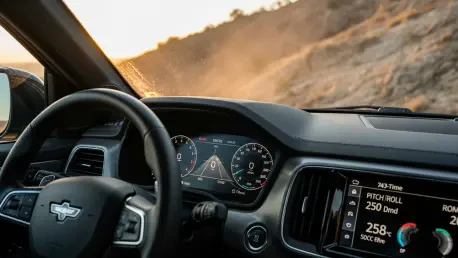
Real-Time Telemetry: Monitoring Vehicle Health and Diagnostics
Beyond navigation, the transformation of the off-road experience involves a deeper connection to the mechanical state of the vehicle itself. Android Auto has expanded its scope to act as a secondary dashboard for critical telemetry data that traditional instrument clusters might overlook or bury in complex menus. Specialized applications now interface with the vehicle’s CAN bus to display real-time information such as transmission temperature, individual tire pressures, and precise pitch and roll angles. Monitoring these variables is essential when navigating technical rock gardens or deep mud where overheating or a rollover is a constant risk. By centralizing this data alongside the map, the system allows the driver to maintain situational awareness without taking their eyes off the trail for extended periods. This integration also extends to managing auxiliary equipment, such as winch load monitors and light bar controls, which can now be adjusted directly through the infotainment screen.
Advancing the Digital Trailhead: Strategic Success and Future Steps
The transition toward a fully integrated digital experience in the off-road sector proved to be a significant turning point for both casual weekend warriors and professional overlanders. This evolution demonstrated that software was just as vital as physical modifications like lift kits or lockers when it came to conquering difficult terrain. Looking ahead, the focus shifted toward more predictive capabilities, where AI-driven analysis of terrain data could suggest the optimal tire pressure or drive mode before the driver even reached a specific obstacle. For those seeking to maximize their time in the wild, the recommendation was to invest in high-quality hardware that supported the latest wireless protocols and to keep mapping databases updated regularly. By embracing these technological advancements, explorers ensured that their journeys were not only more adventurous but also significantly more calculated. The reliance on fragmented tools was replaced by a cohesive system that redefined the boundaries of vehicular exploration.